A lost citadel in the Montagne Noire
A few months ago, I took a walk in the forests of the Montagne Noire, south-west France. I waded rivers and fought dense vegetation in a bid to became one of the first people since the 12th century to visit the remains of a lost castrum – or fortified village. I say ‘lost’ because, until a year ago, it was unknown to archaeologists and historians. Although more research needs to be done, this citadel was probably called Mont-Revel, and it is mentioned in only one surviving contemporary source – an act authorising its construction signed in 1174.
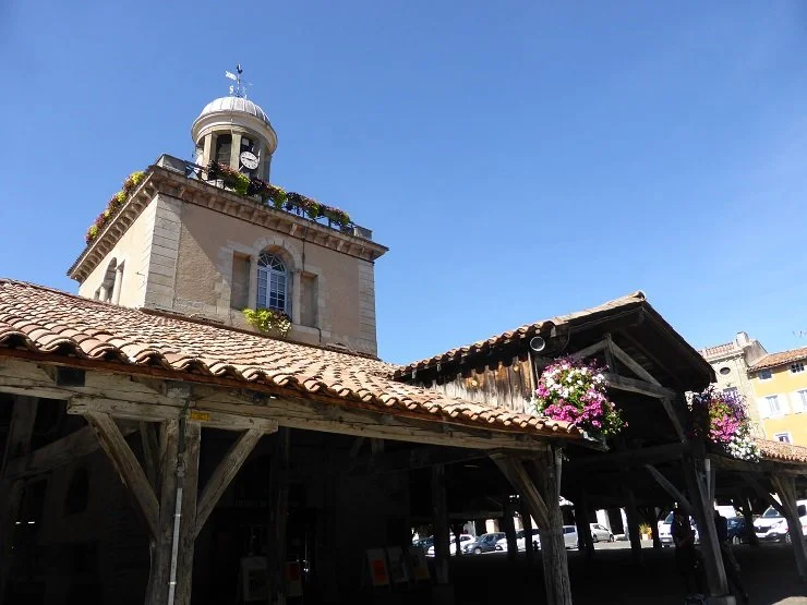
The market hall in the royal bastide of Revel.
Part of the reason it remained undiscovered for so long was its name. In the mid-18th century, the authors of Histoire générale de Languedoc suggested that Mont-Revel had given its name to the royal bastide of Revel founded in 1342. It was logical to assume that the two settlements were near-neighbours, so there was no reason to look for Mont-Revel in a remote valley fifteen kilometres (ten miles) to the south-east. Then, in the 20th century local historians discovered ancient foundations on the hillside above Revel and concluded they must be part of the lost castrum.
More recently, several new theories were put forward to explain the origin of Revel’s name, and this re-opened the question of where exactly Mont-Revel may have stood, if it had ever been built at all. In the act of August 1174, Roger Trencavel, viscount of Carcassonne, gave a hill to his vassals Isarn Jourdain and Bertrand de Saissac where they were to build a château. Trencavel’s objective was almost certainly to strengthen his defences against the counts of Toulouse with whom he and his family were at war for much of the 12th century in a conflict called la Grande Guerre Méridionale, a war which at times involved the kings of Aragon, England and France. But there is no mention of Mont-Revel in contemporary accounts of the Albigensian Crusade which started 35 years later. In contrast, there are frequent references to the Saissac family’s principal château at Saissac. Perhaps Isarn Jourdain and Bertrand had lacked the time or money to build their new castrum.
In 2018, a friend of mine, Jean-Paul Calvet, heard about some intriguing ruins hidden in the forest between Saissac and a village called Verdun-en-Lauragais where the Saissac family had built a castrum in 1152. I bumped into Jean-Paul shortly after he had made his first exploratory visit. We stood on a street corner in Revel and his eyes sparkled with excitement. He was sure he had found Mont-Revel – the ruins seemed to be the right age and the location was so logical. When I told him I would love to go there because it might be interesting for my next book, he promised to give me a private tour when he had time. But Monsieur Calvet is president of the Revel history society and a keen archaeologist. He never has time, particularly while he is in the midst of writing a five-volume history of the royal bastide of Revel.
‘Where is it?’ I asked him. ‘I’ll go there by myself.’
‘It’s difficult to find because there are no paths and the forest is dense, but if you can reach the confluence of the river Lampy and a stream called des Roques, the castrum lies between them a little way upstream.’
My first attempt at the end of 2018 ended in failure. I tried approaching the site from the north and ended up stuck in a rocky ravine choked with impenetrable vegetation. I found the ruins of a large dwelling – maybe a mill, but certainly not a fortified village. Towards the end of winter, I tried again, hoping to find an easier passage now that the undergrowth had died back. This time I decided to start from the south and follow the left bank of the Lampy, something that proved easier said than done. Bramble thickets, dense holly, fallen trees, rocky banks and endless side tributaries made a journey of less than two kilometres feel more like a week-long expedition in the jungle. At one point I decided it would be easier to cross the river, and I took off my shoes and socks, rolled up my trousers and waded knee-deep through the icy torrent, but the right bank proved to be just as challenging. I began to understand why Mont-Revel had kept its secret for so long.
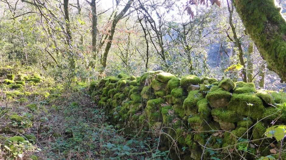
Eventually, I reached the confluence and crossed the Lampy for a second time. I skirted a cliff and began to climb a steep slope. Before long I stood on a line of fallen stones, covered in a thick coat of bright green moss. I paused and looked around me. Could this be part of the castrum’s defences? From Jean-Paul’s description, I was expecting something grander.
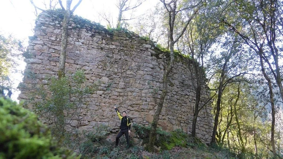
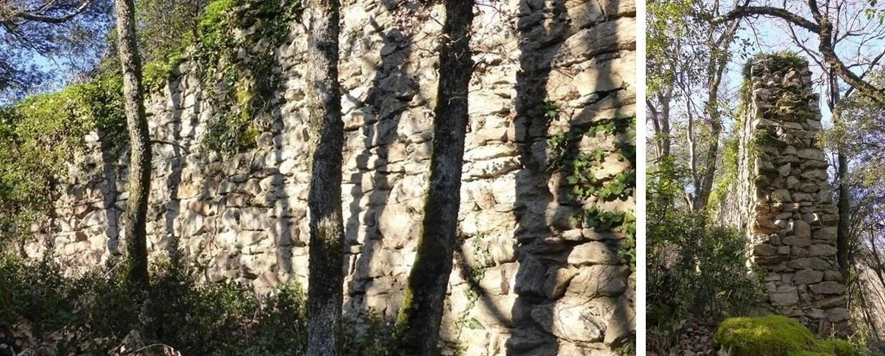
I pushed on, irritated by the army of saplings and fallen branches that scratched my skin and tried to trip me up. And then I stopped in amazement. A vision appeared through the bare trees, a wide expanse of pale-yellow stone gleaming in the winter sun. I picked my way across treacherous rubble-strewn ground and completed a circuit of the only surviving section of massive medieval ramparts. I don’t know its original height, but the wall towered above my head, a solid 1.2 metres thick (four feet), built to resist the attacks of men and the ravages of tim.
It was an eerie experience, knowing that I was one of the first people for several centuries to visit this place and know what it was. No doubt the occasional hunter or woodcutter had passed through since 1174, but they would have had no clue as to its purpose or history.
When I returned home, I emailed the photo at the top of this post to Jean-Paul Calvet. I wanted to prove I had succeeded in my quest. He sent me a reply, which I shall translate.
‘Impressive, isn’t it? Particularly when you think it was unknown to archaeologists. It’s a discovery!!! We’ve located two others. I’ve surveyed one of them and I still have to visit the other. What we have here [in the Montagne Noire] is a true Maginot Line between the Trencavels [viscounts of Carcassonne] and the counts of Toulouse.’
My expedition to Mont-Revel reminded me why I love writing about my adopted region: Occitanie has an extraordinarily rich history, and if you go for a walk with open eyes and open mind, you never know what you might discover.