The extraordinary field system of Montady
Fields are rarely of historical interest, unless they were the site of a notable battle or their surface hides ancient foundations. Montady is an exception, a field system so bizarre, even someone with no interest in history or agriculture will find it astonishing, or even extraterrestrial. You will find it 8 kilometres south-west of Béziers.
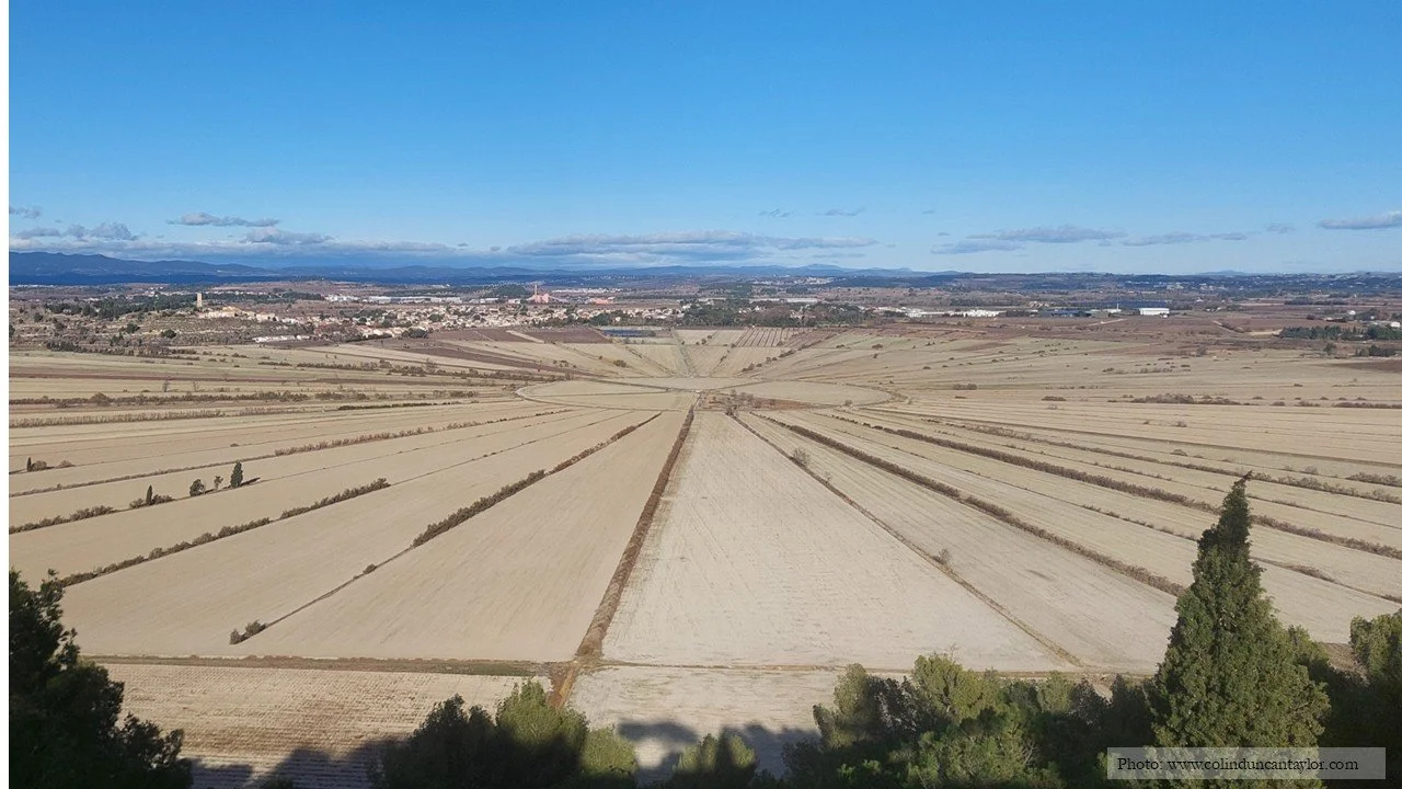
The spoked-wheel fields of Montady in winter - 400 hectares of arable land divided into 80 slices by 120 kilometres of drainage ditches.
A 13TH-CENTURY FEAT OF AGRICULTURAL ENGINEERING
Viewed from the hill to the south, Montady resembles a giant wheel. More than 400 hectares of arable land are divided into 80 slices by spokes, or to be more accurate, 120 kilometres of drainage ditches. This is the result of an extraordinary 13th-century project to transform a disease-ridden swamp into productive farmland. But to understand Montady, we need to go back a lot further in time.
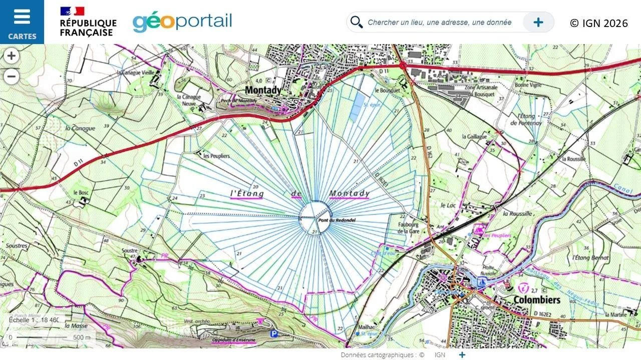
Between 200,000 and 20,000 years ago, intense erosion by the wind created a bowl. There was no way out for rainwater so the bowl became a stagnant lake renowned for spreading disease. In the mid-13th century, the four landowners decided to drain the swamp. In 1347, they obtained authorisation from the Archbishop of Narbonne and set to work. You can see the result of their labours on the map and in my photographs.
HOW IT WORKS
All the ditches bar one carry water towards the centre of the circle. The one running slightly east of due south (on the map, this is just to the left of Mailhac and next to the 22 metres altitude figure) was dug out so that water ran in the other direction. From there, the medieval workers dug a tunnel, 1,345 metres long (nearly 1 mile) and large enough for a person to walk through. It passes beneath the hill of Enserune and, after a sinuous course, resurfaces in the commune of Nissan-lez-Enserune where it joins natural waterways. During its underground journey, this ancient tunnel passes 16 metres underneath the Tunnel de Malpas built several centuries later to carry the Canal du Midi through the same hill. Malpas, incidentally, is the oldest navigational tunnel in Europe, built by Pierre-Paul Riquet in 1679-1680.
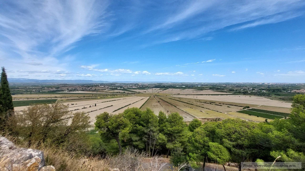
The fields of Montady in September, some crops still waiting to be harvested.
A PRE-ROMAN FORTIFIED SETTLEMENT
I visited Montady twice last year, which is why the first photograph shows bare fields while the third shows a mixture of wheat stubble, sunflowers, vineyards and dark green crops which I was unable to identify from a distance. The main purpose of my second visit was to inspect an older historical site right next to the viewing point. The Oppidum d’Enserune (marked at the bottom of the map) was a fortified Celtic settlement occupied between 575 and 200 BCE, a strategic location where Celts, Greeks, Iberians, Etruscans and Romans traded goods and ideas. As well as excavated ruins, it offers an exceptionally fine and modern museum. I shall write about Enserune in my next article.